Algeria: Algiers the White, the Roman cities and the Sahara
Algeria had been a blank space on my map for years — the biggest country in Africa, sitting just across the water from a coast I knew by heart, and somehow almost no one I knew had been. So I went, with a visa stamped into my passport and a vague plan to draw a line from the sea to the deep desert. I landed in Algiers in the white light of late morning, and the first thing I understood was the nickname: Alger la Blanche, Algiers the White, a city of pale facades climbing in tiers from a blue bay.
The plan, loosely, was this: a few days in Algiers, then inland and east to the Roman cities everyone tells you about and almost no one visits, a pause at Constantine and its impossible bridges, and finally — the part I'd really come for — the long haul south into the Sahara. A capital, some old stones, a city of gorges, and an ocean of sand. What I hadn't quite reckoned with was how cleanly the signal would split the trip in two: dependable across the north, and then, in the great south, simply gone.
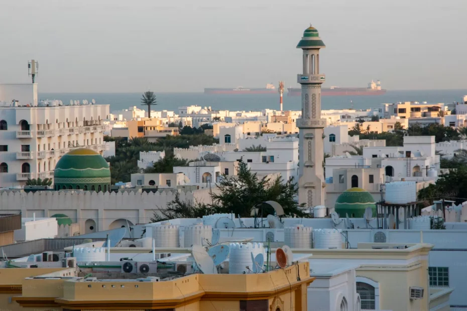
Algiers the White, in tiers above the bay
You don't walk through the Casbah of Algiers so much as fall through it. The old quarter spills down the hillside in a stack of whitewashed houses, blind alleys and stairways, Ottoman doorways and the occasional courtyard glimpsed through a half-open gate — a UNESCO-listed maze that has been lived in for centuries and still is. I got lost almost at once, which is the only honest way to see it, and when I finally wanted to climb back out toward daylight my phone found me without complaint. In the capital the connection was genuinely fine — enough to drop a pin, message my guesthouse, and read up on which gate I'd accidentally wandered out of.
Above the city, things open up and the views come at you all at once. I climbed to Notre-Dame d'Afrique, a basilica perched over the sea, and stood a while watching the bay flatten into haze. Across town the Maqam Echahid, the great concrete monument to the fallen, rises over Algiers like three palm fronds cast in stone, and below it the Bardo and the old museums hold the threads of everything that came before. The whiteness is real — colonial and Ottoman and modern all at once — and from up high the whole city reads like a single bright wall facing the Mediterranean.
« I came for one city the colour of bone above a blue bay, and stayed for the Roman ghosts in the hills and the silence waiting in the south. »
Down at street level I leaned on my phone for the small, useful things — confirming a driver for the days ahead, reading menus I couldn't decipher, checking train times east. Along the coast and in the city the data held up well, which made the logistics of a trip this size untangle themselves quietly while I drank too much coffee and watched the port.
Timgad, Djémila, and the ghosts in the hills
Then came the part that genuinely stopped me. Inland and east, the Roman cities of Algeria sit in the hills with almost no one in them — and they are astonishing. At Timgad, which people call the Pompeii of Africa, an entire colonial town unfolds on a high plain: a grid of paved streets you can still walk, a triumphal arch standing alone against the sky, the stone seats of a theatre, the ruts of cartwheels worn into the road. It's UNESCO-listed and it was nearly empty the day I came, and that emptiness did something to the scale of it. Djémila, set in a fold of green hills, is quieter still and somehow even more complete — temples and forums and houses with mosaics, laid out exactly as a town should be, just missing the people.
Closer to the coast I stopped at Tipasa, where the ruins meet the sea — broken columns and old foundations scattered along a shore of pines and bright water, the waves doing now what they did then. Across all of it the network behaved like a northern thing: solid in the towns, thinner on the long roads between the sites, present when I needed it and patchy when I didn't. I learned, here, to look things up before I set off rather than counting on a signal at the ruins themselves.
Constantine's bridges, and the road to the Sahara
Constantine is a city that shouldn't be possible. It sits astride a deep gorge, split by the canyon of the Rhumel, its districts stitched together by suspension bridges flung high over the void — you cross on foot with the drop falling away beneath your boots and the city humming on both sides. I spent a vertiginous afternoon walking from one side to the other and back, just to feel it. Then I turned south, and the country began to change: drier, emptier, the towns farther apart, the light getting harder by the hour.
Somewhere down the long road toward Ghardaïa, in the M'Zab valley, the modern world thins out and an older one takes over — a cluster of fortified desert towns climbing their hills in tight rings of ochre and white, UNESCO-listed and unlike anywhere else I'd been. This was the threshold. Past here the south proper begins, and the practical truth comes with it: heading on toward the Tassili n'Ajjer with its ancient rock paintings, or the Hoggar around Tamanrasset, you go in an organised group, and you go beyond the reach of the network. The signal that had carried me across the north simply did not follow me into the sand.
Out there the desert does what it has always done. The dunes begin where the road gives up, and the emptiness opens in every direction and does not end. And here the honesty has to come in: across the great south — the Tassili, the Hoggar, the long tracks between oases — coverage gets thin and then it leaves altogether, which is exactly why you travel with a guide and why an offline map is not optional. I'd downloaded mine and let people know my rough plan before the last bars vanished, because out here that is simply common sense. For one long evening I sat on cooling sand watching the colour drain out of an enormous sky, completely unreachable, and it was the hour of the whole trip I think about most.
📶 Thomas's tip
Algeria sits outside the EU, so there's no roam-like-at-home here — set up a dedicated eSIM before you go, and have it active when you land. Across the north — Algiers, the coast, Constantine, the Roman sites — plan on usable data, enough to navigate the Casbah, line up a driver, and check train times. For the great south — Ghardaïa onward to the Tassili and the Hoggar, usually in an organised group — assume the signal will thin or vanish: download an offline map and share your plan before you leave the last town. Check your phone's compatibility in 30 seconds here and find your Algeria plan on the destinations page (if a separate European leg is on your itinerary, a regional EU/EEA plan covers you there too).
What I take away
Algeria gave me the whole span in one trip: a white city stacked above a blue bay, Roman towns standing nearly alone in the hills, a city slung across a gorge, and at the far end the clean, total silence of the Sahara. The signal traced the same line — there across the north when I needed to find my way out of the Casbah or sort the next driver, gone in the south when the sand wanted me to put the phone down. I didn't fight that. I planned around it, and it left the connected days useful and the disconnected evening unforgettable.
— Thomas, somewhere between a white wall and a dune, watching the colour leave the sky.
